iNaturalist.org is an amazing resource featuring millions of species observations from all over the planet, crowdsourced from everyone from career scientists to everyday observers (Citizen Scientists in training!)
As an enthusiastic user/observer/identifier on iNat, the more time I spend exploring this vast community resource, the more rewarding it becomes.
The deeply featured website and current mobile apps do a large of things very well.
However, to get the fluidity and enjoyment that I typically get from browsing other apps like Instagram, I decided to create a map-based explorer that includes highlights from iNaturalist.org.
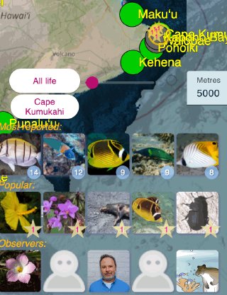
The result is a lite, mobile-aimed (but desktop-capable) interface that quickly shows location/radius-based highlights via the amazing Inat API, using Angular and OpenLayers:
https://natmap.justinthedeeps.com
This is an alternative UI/UX from the current official app(s), which I find more enjoyable for quickly discovering new cool things. I have already noticed dozens of amazing new things via this interface, resulting in scores of ‘faves’ to a bunch of things I haven’t noticed before.
As a scientist, ‘citizen naturalist’ and part-time software/web developer myself, the iNat experience and implementation has been incredibly interesting and enjoyable. This is one small way I can ‘give back’ (and see more cool stuff 😄)
Note there will be bugs in this webapp, and it currently initializes over Hawaii because I designed it in part to emphasize marine species and locations popular to divers. It collects no data from users.
The API has limits, so some patience is warranted with regard to loading times and 429 errors (Too many requests.)
Feedback is welcome!


